Monday, June 30, 2014

Yesterday night mini showers sweaping S,central mithi zone ......

Now Mostly cloudly with some Eastern clouds , it means #Monsoon in near ...
Monsoon to reach pakistan in next 2-3 days.. / Engr-M-Waqas

Valid till 4/5 july:
More pre-monsoon rains predicted in upper pakistan.
A low area pressure lies over north pakistan and adjoining afghanistan.
Monsoon to become active under Himalyas feet in next 2 days.
Monsoon to reach pakistan in next 2-3 days.


Moderate to scattered heavy falls expected late night or early morning times in Lahore,gujranwala,sialkot,gujrat,jhelum,Islamabad,rawalpindi, murree,kashmir and adjoining areas.
Moderate spells of rains expected in mandi bhauddin,chakwal,hazara,peshawar,kohat divisions late night or early morning time in next 3 days.
some isolated dust squalls and rain can be seen insargodha,mianwali, faisalabad sahiwal,DI khan,Multan,Dg khan divisions in next 3 days.

Remaining country to stay mostly dry.While pleasant weather to continue for coastal sindh including karachi with chances of drizzles late tonight and early morning.Same activity for makran coast.This will continue in next few days.
Monsoon onset for sindh seems to be delayed.


This Spell can continue in upper pakistan till thursday/friday.
Temp will ofcourse drop making weather pleasent in much of upper and central country.

Sunday, June 29, 2014

Vagaries Forecast / Rajesh Kapadia .

osted Sunday 29th June Night:

The Current ( Today's ) 200 Jet Stream position.
Today's 300 Jet Stream Position

And the expected normal jet stream position for the season


Will restore to this normal position with a high over Tibet by next 3/4 days.

1. The South West Monsoon is expected to move into Delhi. UP, Uttarakhand and Punjab and parts of MP in the next 3 days.
We say that the showers currently received in Punjab and Delhi NCR are pre monsoon. The current parameter we study s the 200/300 level jet streams. These are taken into consideration today as they will be guiding the Monsoon towards the West, while the sea level trough remains North of normal position.See Charts above...

Delhi NCR will get the thunder showers next 3 days, and would expect Monsoon by Thursday. SW winds will dominate. Cloudy and cooler conditions by then. 
Heavy falls in Punjab and Haryana and west UP. 
Very heavy rains expected in Uttarakhand next 3 days. Caution against flash floods.

The Northern Axis will remain for the next 3 days in the present position, therby bringing down the UAC over W. Bengal to sea level. The Low will be most probably situated over Bangladesh. 
Kolkata and most of G. West Bengal can expect heavy rains on Monday 30th/ Tuesday 1st July and Wednesday 2nd July. Would expect between 35-45 mms/day in Kolkata on Monday and Tuesday. NE States can get very heavy rains from this coming week as the anti clockwise winds from the Low rush straight into the region. Expect extremely heavy falls in Meghalaya.

As the Low moves Eastwards, Rainfall decreases in MP and Odisha. We see a decrease in rains as compared to last few days in Odisha ( BBS) and East MP regions.

2. The feeble off shore trough from Karnataka to Kerala is hosting a UAC off Karnataka. Increase in rains over coastal Karnataka and Kerala next 2/3 days.
South Interior Karnataka and adjoining TN would get some showers. 
Bangalore could see cloudy weather, and some showers of moderate intensity in the day for the next 3 days, Monday could see a thunder shower in some parts. The upper air trough along 12N weakens after Monday. Tuesday and Wednesday will be cloudy ( 31c) and some showers in parts.

Rainfall marginally picking up over coastal Maharashtra from Monday 30th. The Konkan region will see some improved rainfall from Monday thru Wednesday 2nd July, though not up to the mark required. 
Interior Maharashtra and Gujarat would remain devoid of any meaningful rains.

The trough in South India along the 12N line and the UAC off the Chennai coast seems to weaken by Tuesday 1st July. Another day of rains in Chennai and subsequently may decrease from Tuesday.


Mumbai forecast and report was put up yesterday...Yes, seems Colaba heading for its driest June EVER....and rains seem to show a slight improvement from the coming week..more so from Wednesday as declared earlier. A fresh June report tomorrow nigh for Mumbai and Maharshtra...

Pakistan:

The South West Monsoon can be expected to move into Northern areas of Pakistan initially within next 3 days
Next 2/3 days, we can expect thunder showers in Upper Punjab ( Lahore and Rawalpindi), Islamabad, and extreme Northern Pakistan regions as the seasonal low is focused in the far North of the country, and SW winds from the Arabian Sea are blowing towards the Low.

Coastal areas of Sindh and Karachi will be cloudy with light rains in the next 2/3 days. 
Monsoon arrival for Sindh seems to be delayed to some extent.
Central and Upper Sindh will be hot, with places in Balochistan and Sindh reaching 48c.

Friday, June 27, 2014

Pakistan:The Monsoon cover date for Southern coastal Sindh would be 4th/5th July.
 

We can expect light pre Monsoon showers for Karachi from 1st July. Cloudy weather, with strong SW winds would welcome the Monsoon in Karachi in the first week of July.
Squally dust/thunder storms in Sindh and Thar. Sukkur, Larkana and Hyderabad regions and SE Sindh will see very squally weather.


Good pre Monsoon showers in Islamabad, Lahore, Multan and Pakistan Punjab region from 1st July..drop in day temperatures for sure.
Seeing the subsequent progress, we can expect the Monsoon advance into Upper Sindh, Central Pakistan and Pakistan Punjab be around 10/11th.

By Rajesh Kapadia Vagaries

Thursday, June 26, 2014

Good News !! GFS models suggest that **Monsoon expected to Start from 3 july in N,Pakistan ..** .

MeanWhile weak monsoon clouds over lower Sindh giving light showers from 1 july ..

Today mid-level criculation seen over S,tip of Balochistan and Adjoining sindh .. it's run upto Gwadar,Makran,Turbut,Sukkur,Larkana,Dadu in next 36 hrs ....http://ow.ly/i/62jvc
A mid-level criculation seen from N,E Balochistan,S,W kp,central punjab and upper punjab . it drift to E,S-E side and reach S,W punjab in next 36 hrs .....http://ow.ly/i/62jwU

In next 42 hrs, Upper-level criculation again seen over Upper Punjab,S,S kashmir and Adjoining N,W-N india , it's further to move S,E wards ....http://ow.ly/i/62jza
Another low-level criculation seen upto N,W balochistan and N,W sindh in next 36 hrs ..http://ow.ly/i/62jBM

8:30 pm ,Formation of Clouds over S,central Balochistan,N,E balochistan and S,S kpk ..http://ow.ly/i/62jG0
Partly to Cloudly weather continues over lower sindh for few days ......http://ow.ly/i/62jDQ
Light to Moderate rain expected in S,W,central Balochistan and N,E balochistan in next 18 hrs .
Rain alos continues over Kashmir,Islamabad,Rawalpindi,lahore,Multan,Gujranwala .
From today mid-night rain expected over D-G khan,Bahawalpur,Hazara division .
Dust storm also expected over Sukkur,Larkana, divisions in next 24 hrs ....


Wednesday, June 25, 2014

W.D Ending & Monsoon Arrival / Waqas ...

Next 24 hours?
WD ending?
Monsoon arrival date?
Whats in next days?
All details are given in this long range forecast.Please read carefully and try to understand attached map view.

Insha'Allah we pray for this to come true.


Next 24 hours:
Scattered rain/TS expected in upper and central punjab,kashmir twins,kohat and hazara divisions tonight and tomorrow morning.


#WD:

WD interacting with Monsoon moisture causing light to moderate/some heavy rains in upper pakistan while isolated in central parts.It will loose intensity by tomorrow and will end on friday.

As WD ends we see gradual decrease in rain in upper parts.Resulting in dry and humid plus warm days from firday to sunday/monday.


#Monsoon 2014:
Monsoons expected to start in northeast punjab,Islamabad and kashmir from 2/3 july with moderate rain spells.
Meanwhile we see weak monsoon clouds over lower sindh including karachi giving cloudy periods and drizzle/light shower/winds.


Left Pic shows rain amounts estimation during first decade of july.
Right side showing expected Scenerio by GFS model.


#Islamabad:

Rains decreasing in next 3 days but isolated chances of rain will persist.we see rains with breaks from 2 july onward in capital mostly falling on late night/early morning times.

#Punjab:
Sialkot,gujrat,rawalpindi,jhelum,pasrur,narowal,gujranwala will see monsoon rains from 2 july increasing in intensity day by day falling mostly at late night or early morning times.
Lahore,mandi bhauddin,chakwal will receive rains from2/3 july with low intensity but increasing day by day.

Central punjab including faisalabad,sahiwal,jhang,sargodha,mianwali will not be able to get gud rains till 5 july but after that 1-2 rain spells for this region.


south punjab will stay mostly dry in first 10 days of july but there are few chances of light monsoon activity in eastern south punjab in second week of july.
Multan,dg khan will stay mostly dry but chance of surprise TS cant be ruled out due to heat and other conditions favourable for phenomenon.


#KPK:

Hazara divisions including mansehra,haripur,khanpur,noshehra etc will receive monsoon rains starting from 2/3 july onward.
Peshawar to stay dry most of time as monsoon reaches slowly toward west kpk.But can see first monsoon rain during 4-10 july.
central kpk can see scattered rain after 5 july while southern parts to stay dry.


#Sindh:
As mentioned above karachi,mithi,badin,thatta and adjoining coastal belt will remain cloudy time to time from friday onward with chances of drizzle/light shower.A Thunder shower can be expected in these areas after 5 july(30-40% chances)
Proper start of monsoon in sindh seems after 8 july or more.(Will be updated later as things become clear)
Remainign sindh will stay dry and warm.


#Balochistan:

Will remaind dry and warm as we know monsoon recahes balochistan after reaching other parts of pakistan.But kirthar ranges and coastal belt can see clouds and drizzles/light rain during 27-2 july.
Monsoon to reach after mid july.Further details will be updated later.


#kashmir and #Gb:
Kashmir gud days coming for u  Ofcourse most of kashmir to see good rain after 2 july both azad plus jammu kashmir.
Gb will see isolated activity of rain.

Saturday, June 21, 2014

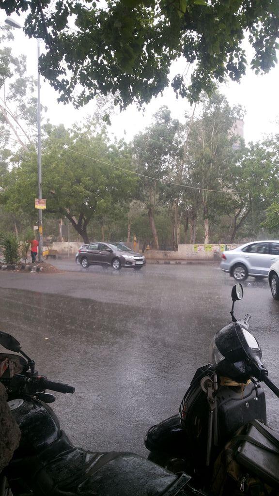
RT@being_delhite : Rain lushing in central delhi/NCR , that's quite relief @weatherofpak ..!!

RT@NBT-Dilli : 
gets a shower and big relief from heat. Rain is here.
Embedded image permalink


Friday, June 20, 2014

Today mid-level criculation again seen over N,central Kpk and N,W-N Balochistan .....
This mid-level criculation push N,E side and reach N,central punjab,S,Kashmir & S,GB in next 12 hrs ..!http://ow.ly/i/5YVUd
Mid-level cricualtion than finally reach N,W-N india in next 24 hrs ..

Another low-level criculation seen over along Balochistan & S,W Sindh coasts in next 18 hrs .. it's run upto Gwadar,Turbat,Makran,Karachi and coastal areas ....http://ow.ly/i/5YVUx

In next 36 hrs , W.D mid-level criculation cross pakistan and Finally reach N,W-N india ..
W.D mid-level criculation reach N,W-N , much active than Pakistan ....http://ow.ly/i/5YVUP
10:30 pm, N,Pakistan and N,W-N india continue to be persistent criculation over central Kp,and S,GB .....!!http://ow.ly/i/5YVUZ
In next 36 hrs , light to moderate rains expected in N,central punjab,Kashmir,Lahore,Peshawar and Rawalpindi ..http://ow.ly/i/5YVVe
Rain also expected in central kp, Islamabad,Gujrat,Taxila and Chakwal in next 18 hrs ..Rains also contnues over Upper kp,Hazara ,banu and kohat ....!http://ow.ly/i/5YVVu
In next 36 hrs ,Moderate to heavy rain also expected in N,W-N india , due to present W.D criculation over N,Pakistan ..http://ow.ly/i/5YVVL 

RT @amernawaz : : It's raining with thunder and lightning in #Rawalpindi... @weatherofpak 

Weak W.D is going to effect Western and Upper Parts of Country ...

BAD News !!GFS models suggest that a Weaking or break #Monsoon over W,S-W coast of india .

Arabian-sea wing of S,W monsoon may go lull after 23-24 june ...

Today mid-upper criculation seen over N,Pakistan .... the mid-upper-level criculation persisting along S,GB,N,E Kp, N,punjab & S,Kashmir in next 48 hrs ..http://ow.ly/i/5YlHx
A mid-level cricualtion expected to Intensify push to N,W-N inida in next 36 hrs ..

A weak W.D is going to effect western and Upper parts of country from tomorrow ...http://ow.ly/i/5YlIJ

In next 36 hrs mid-level criculation seen from N,E Kp,S,S GB,N,central punjab,and W,S-S kashmir ... W.D mid-level criculation push to N,E-N zone and expected to effect N,W-N india in next 48 hrs ....http://ow.ly/i/5YlK3
Another low-level criculation seen over S,central balochistan and N,W sindh in next 36 hrs .. it's expected to push S,E side in next 48 hrs ...http://ow.ly/i/5YlLc
In next 36 hrs , light to Moderate rains continues over Islamabad, Lahore, Kashmir ,Hazara , Di-Khan , Peshawar , Rawalpindi , Gujrat , Gujranwala , Sialkot , Chakwal and Sargodha ...
light rain also expected in South tip of Sindh in next 36 hrs ....http://ow.ly/i/5YlMj
Mean while Isolated  heavy rain also exoected in 1-2 places  can't be ruled out ...http://ow.ly/i/5YlNb 
6:00 pm T-Showers seen over N,W kpk,most of GB , N,E Balochistan ...
Cloudly weather continues N,central punjab,and Kashmir ...


Thursday, June 19, 2014

Forecast for Saturday - Monday ...

Forecast for Weekend 

A weak W.D is going to hit Western and Upper Parts of Country from Saturday ..
Under it's impact interaction Possible between W.D and weak Pre Monsoon winds ....

From Saturday afternoon to Monday Scattered dust Storm and light to Monderate rains expected in #Peshawar,#Hazara,#Di-Khan,#Kohat,#Jhelum,#Islamabad,#Rawalpindi,#Gujrat,#Lahore,#Gujranwala,#Sialkot,#Chakwal,#Sargodha,& #Kashmir ...

Isolated good rain in one or two places can't be ruled out .....!!! 

#Faisalabad,#Sahiwal and adjoining central Punjab can see dusty winds and Slight chances of drizzle , S,S punjab,#Sindh,#Balochistan, will remain hot and dry till some days ..!! 


Credit by :

Muhammad Waqas / @Pakistan Weather Forecast 


Wednesday, June 18, 2014

"A Rainy day " for Belgaum -

Belgaum - "A rainy day "--- some photos --- http://ow.ly/i/5WUY4
 
http://ow.ly/i/5WV29  


Bangalore 5.30pm, T. Clouds crossed from SW with mild showers.. sky ow.ly/i/5WMMW 


5:00 pm,T-Showers seen over N,E-N Balochistan central S,W Kpk ...http://ow.ly/i/5WNqT
Cloudly weather continues over twins and N,Pakistan today as well ....! 


"GFS" models sugguest that mid-level criculation seen over N,Pakistan ..
It's push to N,W-N india in next 36 hrs .. it's Further to move N,E-N zone !http://ow.ly/i/5WNt2  

Today another low-level criculation seen upto  N,cental Sindh to N,W rajasthan ..
this Criculation drift to N,E side and reach S,Punjab ....http://ow.ly/i/5WNJl  
From tomorrow again low-level criculation seen over twins,S-S GB,N,E kpk and S,W Kashmir .. it's runnig over N,W-N india ...

A low-level criculation also seen over central Balochistan and central West Sindh in next 24 hrs ....it's poping up over central sindh ....http://ow.ly/i/5WNWS  

From today mid-night more rain expected over Kashmir,Upper Punjab,and upper Kpk ..Rain also expected over Gujranwala,Sargodha,Hazara-Malakand divisions ...


Monday, June 16, 2014

Pre Monsoon Arrival N,Pakistan

Updates 16th june, Night !!!!
Detail weather for next 48 hours !!!
First premonsoon showers occured at kashmir and few parts of northeast punjab while many areas in upper punjab got dust storm.
Heat wave will end in upper pakistan from tuesday night. 

Weather next 48 hours:
‪#‎Islamabad‬:
Likely to receive first pre-monsoon rain tonight or tuesday evening/night with gusty winds.
‪#‎Lahore‬:
Likely to receive dusty winds on tuesday evening/night with slight chances of rain on tuesday evening/night or wednesday.
‪#‎Upper‬ Punjab:
Gujranwala,gujrat,jehlum.chakwal.taxila,murree,attock,rawalpindi,sialkot,pasrur,narrowal,mandi bhauddin are likely to receive first rain of the season druing tuesday afternoon to wednesday with strong gusts.
‪#‎Central‬ and ‪#‎South‬ punjab:
Mostly dry and warm weather will continue but heat wave will loose intensity by tuesday.Chances of dusty winds in faisalabad,sargodha divisions with very very less chances of light rain on tuesday/wednesday.
Remaining all parts will stay dry.
‪#‎kpk‬ & ‪#‎Kashmir‬:
Scattered areas in kashmir and Hazara,peshawar,mardan,sawat,noshehra divisions in kpk will get rain on tuesday evening through wednesday.
Reamining parts will remain dry.
‪#‎GB‬:
scattered rains in next 48 hours.
‪#‎Sindh‬:
We see clouds popping up in kutch region of sindh today.Same chances tomorrow with slight chance of rain in sir creek region.
Remaining parts of sindh including karachi will stay dry till some days.
‪#‎Balochistan‬:
kirthar range facing clouds devlopemnt in last 2 days which will continue till next 2 days may cause light rain in makran coast.Other parts will remain hot n dry till many days.

Friday, June 13, 2014

Pre Monsoon for Pakistan in June !!

Pre Monsoon rains expected for Pakisttan in June !

Pre Monsoon rains expected to effect N,Pakistan during next week ..

2-3 good rains expected in upper Punjab mainly #Lahore,#Gujranwala,#Gujrat,#Sialkot,#Jhelum,#Rawalpindi ...

Rains alos expected in (Upper Kpk) #Hazara,#Malakand,#Abbotabad and Peshawar divisions during Monday ..

Cloudly and fast Winds conditions ahead for Central Punjab during this Actvity ..

Pre Monsoon rains also expected to effect S,E and lower Sindh during last week of June ...
#Mithi,#Diplo,#Nanger-Parkar,#Chhor,#Chachro and other parts of Thar get Moderate-Heavy rains ..
Other Parts of lower Sindh may get light to Moderate rains during activity ..

Balochistan,S,Kpk,South punjab, will remain Mostly dry and Hot conditions till Start of July ..

Pre-Monsoon,Na Nauk, Dust storms and Heat wave: Detailed weather forcast for remaining days of june !!!

Pre-Monsoon,Na Nauk, Dust storms and Heat wave:
Detailed weather forcast for remaining days of june !!!

‪#‎Heat‬ wave:
Heat wave expected to be very severe in next 3 days mainly in upper and north pakistan.Temp in Islamabad may cross 43'C and northern hills will give surprising figures too.But this severe heat wave will end up/reduce in coming week InshaAllah In most of upper and central Pakistan.South pak will remain at high temp but a bit drop is expected in next week.
‪#‎Na‬-Nauk:
Cyclone Na-Nauk will have no direct impact on pakistan.But as it will move toward Oman on friday time to time clouds will be seen in Makran, Karachi, Badin ,Thatta and thar region with chances of (40-50%) drizzle/light rain/isolated good showers on friday and saturday, mostly in afternoon friday to saturday.We pray for rain in coastal pakistan.
(SEE THE SECOND IMAGE) 

‪#‎Pre‬-Monsoon:
Most wanted thing of season that is monsoon !!!
Pre-monsoon rains expected to start effecting upper pakistan during next week that is monday or tuesday onward.
We see severe dust storms in upper punjab,peshawar and hazara divisions,Islamabad and kashmir during monday-wednesday.This activity will result a drop in temperatures.
InshaAllah we will see 2-3 good rains in upper punjab mainly‪#‎Lahore‬,‪#‎gujranwala‬,‪#‎Gujrat‬,‪#‎Sialkot‬,‪#‎M‬.B.din,‪#‎Jhelum‬,‪#‎Rawalpindi‬, upper kpk (‪#‎Hazara‬‪#‎malakand‬‪#‎abbotabad‬, parts of peshawar divisions.) Gb and ‪#‎Kashmir‬ during last 2 weeks of june.
Rain intensity would be mostly light to moderate in next week while it would be moderate to some heavy/good in last days of june for these parts.
Central punjab may see only clouds and fast winds during the period not much chances of pre-monsoon.
‪#‎Balochistan‬, south kpk, south punjab will remain mostly dry and hot.
‪#‎Sindh‬:
Light pre-monsoon activity will effect lower and southeastrn sindh adjoining indian border during last week of june.Its early to specify the area but an estimation shows the focus over badin, thatta, mithi, sir-creek,hyderabad,karachi.

A light to good rain may occur in lower sindh during last week of June inshaALLAH.
‪#‎Dust‬ storms:
Due to severe heat wave in country central parts of country faced severe gale today including multan,dg khan, faisalabad, rahim yar khan, tuba tek singh and adjoining area.
This trend can continue in next 2 days as well but not much chances of rain.Drizzle or light rain may be result only.

Lahore,faisalabad,sahiwal,jhang,pakpattan and adjoining areas may see dusty winds and drizzle/light rain on friday afternoon/evening.
Dusty winds may also be seen in upper punjab and twins. 

Wednesday, June 11, 2014

#Cyclone Nanauk Update

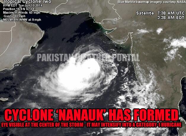
Cyclone ‘Nanauk’ has formed in the Arabian sea

First tropical cyclone in the region in 2014

Embedded image permalink
Cyclone ‘Nanauk’ is now 878 km south of Karachi while 660 km southwest of Mumbai and 990 km southeast of Masirah, Oman. It has started moving in a WNW direction towards Oman. In the next 12 to 24 hours it is expected to further intensify into a category-1 hurricane. On June 14 late/June 15, it may weaken significantly before hitting central Oman as a low pressure or a depression. Following is the current status of the storm;
  • Winds: 65 mph to 80 mph.
  • Movement: WNW
  • Pressure: 992 mbar
  • UNDER THREAT: Oman

Under the influence of a tropical cyclone, chances are maintained at ‘high’ by PWP for the pre-monsoon drizzle/light rain in coastal including Karachi and adjoining south-eastern Sindh around June 14/15 (with -2, +2 day error) as few stray thunderclouds may form over coastal Pakistan. On June 14/June 15, chances of light rain in Gwadar district .h

Tuesday, June 10, 2014

#Cyclone "Nanauk" Update

CYCLONE 'NANAUK' Current Status and Intensity Update: 
Soon it will become a full blown Cat-1 Cyclone. 
878 Km Away From Karachi
Pressure is Now 986
Winds 90+/Km/Hr ..

7:00 pm Visible shows that,02A "Nanauk" Cyclone over E,central Arabian-Sea ..!

Yesterday Analysis shows 95A LOW-Pressure over E,central-Arabian-Sea shows that it's has intensified into a Deep Depression becoming a "Nanauk" Cyclone ..!!
Arabian-Sea cyclone intensified to dirft N,W-N derection ..
Satellate shows , Arabian-Sea cyclone 02A slowly taking shape in E,central Arabian-Sea near #Goa coast ..

JTWC Report
~~~~~~~~~~~


TROPICAL CYCLONE (TC) 02A (TWO), LOCATED APPROXIMATELY 325 NM 
SOUTHWEST OF MUMBAI, INDIA, HAS TRACKED NORTH-NORTHWESTWARD AT 08 
KNOTS OVER THE PAST SIX HOURS. ANIMATED INFRARED (IR) SATELLITE 
IMAGERY DEPICTS AN INCREASINGLY DEFINED LOW LEVEL CIRCULATION CENTER 
WITH FLARING CENTRAL CONVECTION AND BROKEN CONVECTIVE BANDING ALONG 
THE WESTERN PERIPHERY. A 092236Z SSMI 85 GHZ MICROWAVE IMAGE 
INDICATES INCREASED CONSOLIDATION IN THE LOW LEVELS AS THE SYSTEM 
HAS BECOME MORE TIGHTLY WRAPPED WHILE THE CONVECTIVE STRUCTURE OF 
SYSTEM HAS REMAINED MARGINAL OVER THE PAST 12 HOURS. THE INITIAL 
POSITION IS BASED UPON THE AFOREMENTIONED SATELLITE IMAGERY WITH 
FAIR CONFIDENCE. THE INITIAL INTENSITY HAS BEEN ASSESSED AT 35 KNOTS 
BASED UPON THE TIGHTLY WRAPPED STRUCTURE SEEN IN THE IMAGERY AS 
DVORAK INTENSITY ESTIMATES FROM PGTW REMAIN AT 30 KNOTS. UPPER LEVEL 
ANALYSIS REVEALS THE SYSTEM IS SOUTH OF THE SUBTROPICAL RIDGE (STR) 
AXIS WITH MODERATE (15 TO 20 KNOTS) LEVELS OF VERTICAL WIND SHEAR 
(VWS) AND GOOD EQUATORWARD OUTFLOW. TC 02A IS CURRENTLY TRACKING 
NORTH TO NORTHWESTWARD ALONG THE MID TO DEEP-LAYER REFLECTION OF A 
NORTH-SOUTH ORIENTED STR STEERING RIDGE LOCATED OVER INDIA. THE 
SYSTEM IS FORECAST TO BEGIN TO TURN WESTWARD IN THE NEXT DAY AS 
ANOTHER STR BUILDS NORTH OF THE SYSTEM AND BECOMES THE DOMINANT 
STEERING INFLUENCE. GRADUAL INTENSIFICATION IS EXPECTED THROUGH TAU 
72, REACHING 70 KNOTS, AS EXTREMELY CONDUCIVE SEA SURFACE 
TEMPERATURES AND GOOD OUTFLOW CONTINUE. INCREASING VWS AFTER TAU 72, 
WILL START A SLOW WEAKENING PROCESS AS THE SYSTEM BEGINS TO APPROACH 
OMAN. LIMITED NUMERIC MODEL GUIDANCE IS IN FAIR AGREEMENT WITH THE 
WESTWARD TRACK WITH SOME SLIGHT DIFFERENCES IN TRANSLATIONAL TRACK 
SPEED. BASED ON THIS, THERE IS LOW CONFIDENCE IN THE FORECAST. 
MAXIMUM SIGNIFICANT WAVE HEIGHT AT 100000Z IS 12 FEET ..