- Another spell of moderate rain likely in #Delhi-NCR from early morning of 22nd Jan to 23rd afternoon. Rain could start around 5:30am in the morning. On & off spells to continue for the whole day. Average rainfall during this spell would be around 20 mm.

Monday, January 20, 2014
Ow.ly Uploaded By @tanveerdharmani
Sunday, January 19, 2014
BLOGGER ╚►Image - Uploaded By @tanveerdharmani
A shallow westerly wave is affecting western parts of Balochistan and expected to extend to upper parts of the country from Tuesday (afternoon/evening) that may persist for next 36 to 48 hours. Mainly cold and dry weather is expected in most parts of the country. However, partly cloudy to cloudy weather conditions are expected to prevail in upper parts of the country and there are chances of light rain (with light snowfall over the hills) is expected at isolated places of Kashmir, Gilgit-Baltistan, Rawalpindi, Gujranwala, Lahore, Sargodha, Malakand and Hazara divisions during Tuesday/Wednesday.
THE BILLION CLUB ..WEATHER .. 19 JAN 2014(24 HRS ENDING 8.30 AM)@tanveerdharmani
A) CHINA AND SURROUNDING WEATHER .. 19 JAN 2014 .. Population :135 crores The country carries 3 times baggage of land than India .. ...
Thursday, January 16, 2014
Uploaded By @tanveerdharmani @rockixxnblogspot.com
Most parts of country may experience passing clouds today and tomorrow.
Some chances of drizzle in Chaman, Dalbandin, Zhob, Quetta later today and Kohat, Hazara, Muree, Islamabad, Sargodha, Lahore, Sialkot, Gujrawala tomorrow morning.
Very light snow possible in Muree, GB and Kashmir.
Mostly clear and dry for Sindh including Karachi however passing clouds expected esp in western and upper Sindh later today and tomorrow.
Chances of rain for Makran on Monday persist.
Monday, January 13, 2014
MOST POWERFUL WESTERN DISTURBANCE of 2014 SPOTTED:
MOST POWERFUL WESTERN DISTURBANCE of 2014 SPOTTED:
For past 1 week I'm following a Strong pattern over COLA Long Range Forecast Model and as per Different Calculations and Long Range GFS Readings it has been Confirmed that a Very Strong Westeren Disturbance System (WD) will Start effecting Parts of Pakistan from late 25th Jan Onwards and will Grip most of the Country from late 27th Jan except eastern and Coastal Sindh entire Pakistan May get long awaited Heavy Downpours / thunderstorms and moderate to Heavy Snowfall over Mountainous Range.
Karachi may get some lite Showers as well @ 30% Rain Probability.
P.S: This is a long Range Forecast and may Change due to Different Jet Streams Interruptions across the globe.

Sunday, January 12, 2014
Blogger: Image - Uploaded By @tanveerdharmani
Few days back this western disturbance was predicted to drop good rain (snow over hilly areas) over large parts of the country including Karachi. This Western system is now weak, it can bring isolated shower to parts of Balochistan (light snow over hilly areas) and some northern areas of the country on January 12.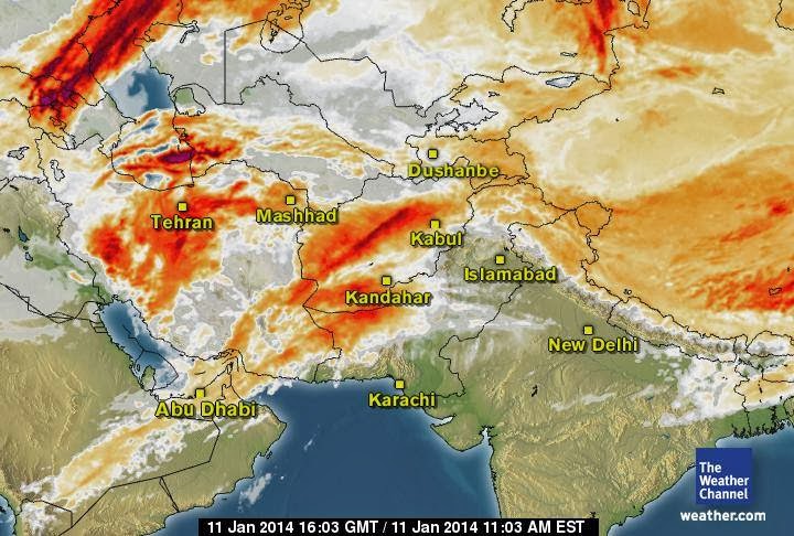
vagaries of the weather ©: Posted Friday Night:Friday was dry over the sub-c...
vagaries of the weather ©: Posted Friday Night:
Friday was dry over the sub-c...: Posted Friday Night: Friday was dry over the sub-continent...isolated rain occurred in Kashmir. A few spots, very isolated , saw light rai...
Friday was dry over the sub-c...: Posted Friday Night: Friday was dry over the sub-continent...isolated rain occurred in Kashmir. A few spots, very isolated , saw light rai...
Subscribe to:
Posts (Atom)