Friday, June 13, 2014

Pre Monsoon for Pakistan in June !!

Pre Monsoon rains expected for Pakisttan in June !

Pre Monsoon rains expected to effect N,Pakistan during next week ..

2-3 good rains expected in upper Punjab mainly #Lahore,#Gujranwala,#Gujrat,#Sialkot,#Jhelum,#Rawalpindi ...

Rains alos expected in (Upper Kpk) #Hazara,#Malakand,#Abbotabad and Peshawar divisions during Monday ..

Cloudly and fast Winds conditions ahead for Central Punjab during this Actvity ..

Pre Monsoon rains also expected to effect S,E and lower Sindh during last week of June ...
#Mithi,#Diplo,#Nanger-Parkar,#Chhor,#Chachro and other parts of Thar get Moderate-Heavy rains ..
Other Parts of lower Sindh may get light to Moderate rains during activity ..

Balochistan,S,Kpk,South punjab, will remain Mostly dry and Hot conditions till Start of July ..

Pre-Monsoon,Na Nauk, Dust storms and Heat wave: Detailed weather forcast for remaining days of june !!!

Pre-Monsoon,Na Nauk, Dust storms and Heat wave:
Detailed weather forcast for remaining days of june !!!

‪#‎Heat‬ wave:
Heat wave expected to be very severe in next 3 days mainly in upper and north pakistan.Temp in Islamabad may cross 43'C and northern hills will give surprising figures too.But this severe heat wave will end up/reduce in coming week InshaAllah In most of upper and central Pakistan.South pak will remain at high temp but a bit drop is expected in next week.
‪#‎Na‬-Nauk:
Cyclone Na-Nauk will have no direct impact on pakistan.But as it will move toward Oman on friday time to time clouds will be seen in Makran, Karachi, Badin ,Thatta and thar region with chances of (40-50%) drizzle/light rain/isolated good showers on friday and saturday, mostly in afternoon friday to saturday.We pray for rain in coastal pakistan.
(SEE THE SECOND IMAGE) 

‪#‎Pre‬-Monsoon:
Most wanted thing of season that is monsoon !!!
Pre-monsoon rains expected to start effecting upper pakistan during next week that is monday or tuesday onward.
We see severe dust storms in upper punjab,peshawar and hazara divisions,Islamabad and kashmir during monday-wednesday.This activity will result a drop in temperatures.
InshaAllah we will see 2-3 good rains in upper punjab mainly‪#‎Lahore‬,‪#‎gujranwala‬,‪#‎Gujrat‬,‪#‎Sialkot‬,‪#‎M‬.B.din,‪#‎Jhelum‬,‪#‎Rawalpindi‬, upper kpk (‪#‎Hazara‬‪#‎malakand‬‪#‎abbotabad‬, parts of peshawar divisions.) Gb and ‪#‎Kashmir‬ during last 2 weeks of june.
Rain intensity would be mostly light to moderate in next week while it would be moderate to some heavy/good in last days of june for these parts.
Central punjab may see only clouds and fast winds during the period not much chances of pre-monsoon.
‪#‎Balochistan‬, south kpk, south punjab will remain mostly dry and hot.
‪#‎Sindh‬:
Light pre-monsoon activity will effect lower and southeastrn sindh adjoining indian border during last week of june.Its early to specify the area but an estimation shows the focus over badin, thatta, mithi, sir-creek,hyderabad,karachi.

A light to good rain may occur in lower sindh during last week of June inshaALLAH.
‪#‎Dust‬ storms:
Due to severe heat wave in country central parts of country faced severe gale today including multan,dg khan, faisalabad, rahim yar khan, tuba tek singh and adjoining area.
This trend can continue in next 2 days as well but not much chances of rain.Drizzle or light rain may be result only.

Lahore,faisalabad,sahiwal,jhang,pakpattan and adjoining areas may see dusty winds and drizzle/light rain on friday afternoon/evening.
Dusty winds may also be seen in upper punjab and twins. 

Wednesday, June 11, 2014

#Cyclone Nanauk Update

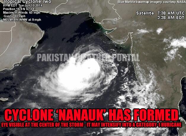
Cyclone ‘Nanauk’ has formed in the Arabian sea

First tropical cyclone in the region in 2014

Embedded image permalink
Cyclone ‘Nanauk’ is now 878 km south of Karachi while 660 km southwest of Mumbai and 990 km southeast of Masirah, Oman. It has started moving in a WNW direction towards Oman. In the next 12 to 24 hours it is expected to further intensify into a category-1 hurricane. On June 14 late/June 15, it may weaken significantly before hitting central Oman as a low pressure or a depression. Following is the current status of the storm;
  • Winds: 65 mph to 80 mph.
  • Movement: WNW
  • Pressure: 992 mbar
  • UNDER THREAT: Oman

Under the influence of a tropical cyclone, chances are maintained at ‘high’ by PWP for the pre-monsoon drizzle/light rain in coastal including Karachi and adjoining south-eastern Sindh around June 14/15 (with -2, +2 day error) as few stray thunderclouds may form over coastal Pakistan. On June 14/June 15, chances of light rain in Gwadar district .h

Tuesday, June 10, 2014

#Cyclone "Nanauk" Update

CYCLONE 'NANAUK' Current Status and Intensity Update: 
Soon it will become a full blown Cat-1 Cyclone. 
878 Km Away From Karachi
Pressure is Now 986
Winds 90+/Km/Hr ..

7:00 pm Visible shows that,02A "Nanauk" Cyclone over E,central Arabian-Sea ..!

Yesterday Analysis shows 95A LOW-Pressure over E,central-Arabian-Sea shows that it's has intensified into a Deep Depression becoming a "Nanauk" Cyclone ..!!
Arabian-Sea cyclone intensified to dirft N,W-N derection ..
Satellate shows , Arabian-Sea cyclone 02A slowly taking shape in E,central Arabian-Sea near #Goa coast ..

JTWC Report
~~~~~~~~~~~


TROPICAL CYCLONE (TC) 02A (TWO), LOCATED APPROXIMATELY 325 NM 
SOUTHWEST OF MUMBAI, INDIA, HAS TRACKED NORTH-NORTHWESTWARD AT 08 
KNOTS OVER THE PAST SIX HOURS. ANIMATED INFRARED (IR) SATELLITE 
IMAGERY DEPICTS AN INCREASINGLY DEFINED LOW LEVEL CIRCULATION CENTER 
WITH FLARING CENTRAL CONVECTION AND BROKEN CONVECTIVE BANDING ALONG 
THE WESTERN PERIPHERY. A 092236Z SSMI 85 GHZ MICROWAVE IMAGE 
INDICATES INCREASED CONSOLIDATION IN THE LOW LEVELS AS THE SYSTEM 
HAS BECOME MORE TIGHTLY WRAPPED WHILE THE CONVECTIVE STRUCTURE OF 
SYSTEM HAS REMAINED MARGINAL OVER THE PAST 12 HOURS. THE INITIAL 
POSITION IS BASED UPON THE AFOREMENTIONED SATELLITE IMAGERY WITH 
FAIR CONFIDENCE. THE INITIAL INTENSITY HAS BEEN ASSESSED AT 35 KNOTS 
BASED UPON THE TIGHTLY WRAPPED STRUCTURE SEEN IN THE IMAGERY AS 
DVORAK INTENSITY ESTIMATES FROM PGTW REMAIN AT 30 KNOTS. UPPER LEVEL 
ANALYSIS REVEALS THE SYSTEM IS SOUTH OF THE SUBTROPICAL RIDGE (STR) 
AXIS WITH MODERATE (15 TO 20 KNOTS) LEVELS OF VERTICAL WIND SHEAR 
(VWS) AND GOOD EQUATORWARD OUTFLOW. TC 02A IS CURRENTLY TRACKING 
NORTH TO NORTHWESTWARD ALONG THE MID TO DEEP-LAYER REFLECTION OF A 
NORTH-SOUTH ORIENTED STR STEERING RIDGE LOCATED OVER INDIA. THE 
SYSTEM IS FORECAST TO BEGIN TO TURN WESTWARD IN THE NEXT DAY AS 
ANOTHER STR BUILDS NORTH OF THE SYSTEM AND BECOMES THE DOMINANT 
STEERING INFLUENCE. GRADUAL INTENSIFICATION IS EXPECTED THROUGH TAU 
72, REACHING 70 KNOTS, AS EXTREMELY CONDUCIVE SEA SURFACE 
TEMPERATURES AND GOOD OUTFLOW CONTINUE. INCREASING VWS AFTER TAU 72, 
WILL START A SLOW WEAKENING PROCESS AS THE SYSTEM BEGINS TO APPROACH 
OMAN. LIMITED NUMERIC MODEL GUIDANCE IS IN FAIR AGREEMENT WITH THE 
WESTWARD TRACK WITH SOME SLIGHT DIFFERENCES IN TRANSLATIONAL TRACK 
SPEED. BASED ON THIS, THERE IS LOW CONFIDENCE IN THE FORECAST. 
MAXIMUM SIGNIFICANT WAVE HEIGHT AT 100000Z IS 12 FEET ..