Friday, May 30, 2014

#Rainy day in Twins

RT@Muhammad Waqas @weatherofpak ‪‎
Via facebook for Web,4:05 pm 

 #Dark weather here At #islamabad...Thunder sounds...#Duststorm ..rain on way #Lights on due to much #darkness !!!!   http://ow.ly/i/5JOwb


#Rain in Near Pasrur ....

‪#Muhammad Usman jajja :: @weatherofpak Today ‪#‎rain‬ with‪#‎thunderstorm lushes near ‪#‎Pasrur‬ .
Two shot of one #‎lighting‬ strike ...! http://ow.ly/i/5JKgp 

Thursday, May 29, 2014


5:30 pm ,T-Showers seen over N,E balochistan and upper Sindh ...
T-Showers continues over N,E-N balochistan , West punjab , North central Kp , N,W punjab & kashmir ..! http://ow.ly/i/5J4G4 
T-Strom activity over N,E balochistan , S-E kp & west punjab ..http://ow.ly/i/5J4I9 
Today low-level criculation again seen over N,pakistan ...it's through seen upto central punjab,N,E k.p, S,E Gilgit and S,W-S kashmir , it's expected to drift to N,E wards in next hours... 

From 31th may , A W.D low-level criculation is going to effect N,Pakistan,upper and western parts of Pakistan during friday to sunday .. heat wave will down in upper parts of the country due to this W.D ..
from tomorrow rain with gusty winds expected in upper Punjab ,light rain expected in  some parts of South punjab,
light rain expexted in faisalabad,Sahiwal,Pak-pattan,Okara,Jhang. Mostly dry and warm weather on thursday in KPK but light rain expected in DI khan & Bannu divisions.
From today evening rain-thunderstorms alos exoected in Zhob & Quetta divisions . other parts of Balochistan remain dry ..

Kashmir and Gilgit see thunderstorms and light to Moderate rain from tomorrow .

Some chances of light rain expected in uppper sindh on thursday evening/night including Dadu , Nawabshah , Larkana , Jacobabad ...! 

#Pakistan weather Forecast from Thursday to Sunday

Detailed weather forcast for next 4 days(Thursday-sunday) !!!
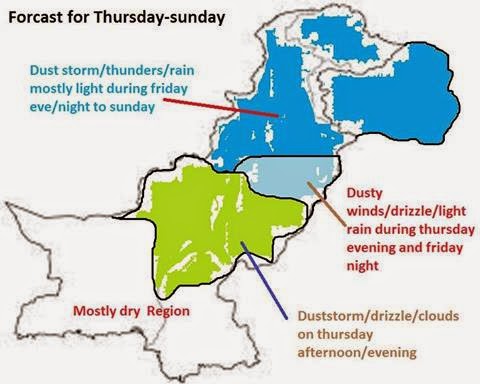
A weak WD is going to effect upper and western parts of country during friday to sunday.Under its impact heat wave will loose intensity in upper parts of country only.
Mainly light rain/ drizzle expected from this spell but some upper parts can get moderate rain.Nothing for south punjab sindh so farmers need not to worry.
‪#‎Islamabad‬ will stay very warm on thursday and friday but chances of thuderstorms/rain in friday afternoon/evening till sunday.
‪#‎KPK‬ mostly dry and warm on thursday but DI khan,bannu divisions can see dusty winds and light rain in afternoon/evening.
Then from friday afteroon to sunday many areas of peshawar,di khan, bannu, kohat, hazara, malakand, mardan, sawabi, charsada, sawat, dir etc will see scattered thundestorms/rain.
‪#‎Sindh‬ very hot weather expected in whole province.But some chances of thunderclouds/duststorm/drixxle in upper sindh including nawabshah,larkana,dadu,jaccobabad on thursday afternoon/evening.
Karachi and other parts will stay warm and dry.
‪#‎South‬ punjab including multan,vihari,DG khan,rajin pur, bahawalnagar,rahim yar khan may see dusty winds/drizzle on thursday afternoon but very warm weather expected from friday onward.
‪#‎Central‬ punjab including faisalabad,sahiwal,pak pattan, okara, jhang may see dusty winds/gale on friday evening/night and saturday with chances of drizzle/light rain(ver less chances of rain).
‪#‎Upper‬ punjab including Rawalpindi, sargodha, mianwali, gujrat, jhelum, Attock, chakwal, mandi bhauddin, may see dusty winds/light rain during friday evening to sunday.
Gujranwala and Lahore divisions, sialkot can see dusty winds and slight chances of drizzle/light rain during the period.
‪#‎Balochistan‬ Quetta,zhob divisions will see isolated thuderstorms on thursday afternoon/evening.But mostly dry and very warm weather expected in all other parts of province.
‪#‎Kashmir‬ And ‪#‎GB‬:
Scattered thudrstorms with chances of light to moderate rain mostly falling during friday afternoon to sunday.

By: Muhammad Waqas

Tuesday, May 27, 2014

BB-3 Effect ..

BB-3 Effect !
In Orissa, Kesinga records 280 mms and Titalgarh 277 mms in 24 hrs...what an effect of BB-3 ! 
Titalgarh's 277 mms in 24 hrs is the highest EVER for this station for any month.Prevoius was 266 mms in Aug 1967.
The days high was 25c, 17c BELOW NORMAL and low 14.5c, 13c BELOW NORMAL !!14.5c is the lowest ever for May, previous was 19.8c in 1979...
Normal avg rain for May is 33 mms !!

Bhavanipatna in Orissa saw 259 mms... 
Posted by Rajesh Kapadia in Vagaries of Weather

Saturday, May 17, 2014

MW-4 (Part-2) 2014...Seasonal Quantum Performance of SWM....17th May 2014

Very Briefly, explaining the Factors considered for Seasonal Forecast:

To take and assess the SWM performance, we refer back to the MW-4 (Part-1). We have to take into consideration most of the 15 parameters (Gowariker Method) before making an assessment, and these have to be analysed one by one. The prominent among the 15 are , ENSO, March temperatures of North India and East Coast, Himalayan Snow cover till March and SOI to name a few.
Of-course, I am not going to take each and every one of the 15 here, but, derive at an estimate on these basis and on the new modeldeveloped. I hope readers of vagaries trust that I have tried my best to estimate as accurately as possible.

Most of the studies on LRF of Indian monsoon rainfall were based on empirical or statistical techniques till 2010. IITM, Pune has recently implemented the state-of-the-art coupled climate model, the Coupled Forecasting System (CFS) developed by the National Centers for Environmental Prediction (NCEP), USA. These statistical techniques range from simple correlation analysis to advanced procedures.

Vagaries' View Point:

I still have faith, and believe in the "Gowariker Method" with 16 parameters. The results of this old but proven method has been successful. For Vagaries' forecast and analysis made in the "Arrival and quantum Monsoon Watch" series, I combine a few of them along with Dynamical models for a personal analysis and estimate. 
15 initial parameters from the months March, April and May are used to analyse and forecast the simulation of Indian monsoon rainfall during June to October. These initial conditions were carefully selected to span the evolution of both the atmosphere and ocean.
Calculating the amount of rainfall, region wise, is of utmost importance, as SWM contributes to almost 80% of the annual total rainfall over India.

The performance of Vagaries' Monsoon Watch Quantum analysis is evaluated for the amount of summer monsoon rainfall over Indian monsoon region during June to SWM withdrawal in 2 phases. (June/July and August/September).

The 500 hpa parameter is of importance in April. The mean latitudinal location of the 500 hpa ridge along 75°E in April over India, first identified by Banerjee (1978), is considered to be one of the most important predictors. The mid-tropospheric anticyclone over southern Indiamigrates from 11.5°N in January to its northernmost position of 28.5°N during July. From October, the ridge starts shifting back southward. A more Northward location indicates better performance of the monsoon and vice versa. It also showed that the negative correlation of the March ridge was more dominant with the monsoon rainfall of the peninsular India, while the positive correlation of the April ridge was more dominant with the monsoon rainfall of Northern India.

ENSO factor in arriving at the rainfall amount is also of importance. The interface is the sea surface: that is where the transfers of water (evaporation/precipitation) 
and momentum occur. An accurate coupling of the fast atmosphere to the slow ocean is essential to simulate the ENSO, which in turn can simulate the interannual 
variability of Indian monsoon. Unfortunately, getting an accurate, or near to accurate forecast of the ENSO for the next 2 months is difficult, with no guarantee of accuracy or performance surety.
We see neutral conditions now. But, there is a possibility of a El-Nino event occurring as early as July/August. Now, this would result in "severe" break Monsoon condition in late July or August. That is the last thing we want. But I would not endorse the event as yet. I would give it a 50-50 chance.

Pulses from the Eastern Pacific area, that is S.China sea, would mean depressions and systems originating from the Bay. 'In Situ" systems and systems from the Far east would contribute to the rainfall to the east Coast thru Central India and into Gujarat and even into Sindh (Pakistan). El-Nino, even a mild one, would sort of restrict these pulses, and in fact encourage WDs into coming down south, more South than normal. But, for this, we would have to hope and pray for the Neutral conditions (presently on) to prevail and hang on till September. Again, a 50-50 chance for Neutral conditions.

If we take into account, that the ENSO is today Neutral, but "leaning" towards a El-Nino phase by, say, August, then:

a) Till July end, we can see normal rainfall and progress of the SWM in the Sub-Continent regions. Normal conditions in the Pacific Oceans will send a few "pulses" to create "in situ" systems in the Bay, and the first 2 months will see around 3/4 noteworthy systems traversing the Sub continent. WDs will be few, hence, we can expect a few systems to track towards Central and Northern India, resulting in good rains in the plains of N.India and Central Pakistan regions..and fairly good above normal rains in Nepal.
During the Northern track of the system, the monsoon trough could be pulled far North into the Himalayas, and possibility of "short "break Monsoon in 3rd week of July or near around that time period.
Break monsoon situations, and winds bringing in moisture from the Bay (diverted to the NW directions) will result in excessive rainfall this season in Nepal, more so the Eastern regions. NE states of India will get continuous feeding from the Bay. (Cherrapunji seems the likely candidate for the highest SWM rains).

b) June sees heat wave in Northern India, and Pakistan..Temperatures upto 50c, which can touch places in Balochistan and Sindh by late May, will be prevelent in first 15days of June. Monsoon advances into Central India and North India after 17th June onwards. Monsoon moves into Pakistan in 1st week of July.
  
Very Briefly, explaining the Factors considered for Seasonal Forecast in the 2nd Half of SWM...August and September:

If we take into account, that the ENSO is now Neutral, but "leaning" towards a El-Nino phase by, say, August, then:

a) There will be a drop in the systems originating from the Bay. If at all there will be weak depressions just about reaching Central India and fizzling out. 
Hence could result in rainfall deficit for the NW regions, including lower Sindh in Pakistan. Central India and adjoining areas will be well covered.

b) In such a scenario, even the 200 hpa jet streams would bend slightly Southwards, and the "low" at that level will be dis-lodged. could bring in the odd WD even in July. Could bring some heavy rainfall to Upper Pakistan regions. Hence, rainfall could be normal/excess in rest Northern Pakistan and Kashmir. Though technically they will be Monsoon rains.

c) Due to systems reluctant to track southwards, we may see lesser rains in the Southern Peninsula regions. Even the support to the west coast (South of Mumbai)may be lesser than normal. Hence, rain shadow regions in TN and interior Karnataka may be slightly deficient in August /September. Lesser gradient along the West coast will show lower rainfall in Kerala, specially in August.

d) Break monsoon situations, and winds bringing in moisture from the Bay (diverted to the NW directions) will result in excessive rainfall late season in Nepal, more so the Eastern regions. NE states of India will get continuous feeding from the Bay. 

Rainfall expected in Major Cities for June:

Mumbai: 550-600 mms
Chennai: 70-90 mms
New Delhi: 70-95 mms
Banglore: 90-110 mms
Pune: 120-130 mms.
Surat: 250-280 mms
Kolkata (Alipore)  270-300 mms
Nagpur  150 mms 


This is a very early estimates based absolutely on the situation as it shows and stands today.  
Things, if and when they change (drastically) will be posted and Vagaries readers will be kept well informed, of any variation in the forecast.  
These are my personal views, and should not be depended upon commercially or otherwise. They may differ from other models.


South West Monsoon Advance Map on Current Weather Page
(By: Rajesh Kapadia)
(www.vagaries.in/)